


LAND AUCTION - 746+/- ACRES OFFERED IN 13 TRACTS BETWEEN NEWCASTLE AND BLANCHARD, OKLAHOMA
Wed, Jun 21, 2:00 PM
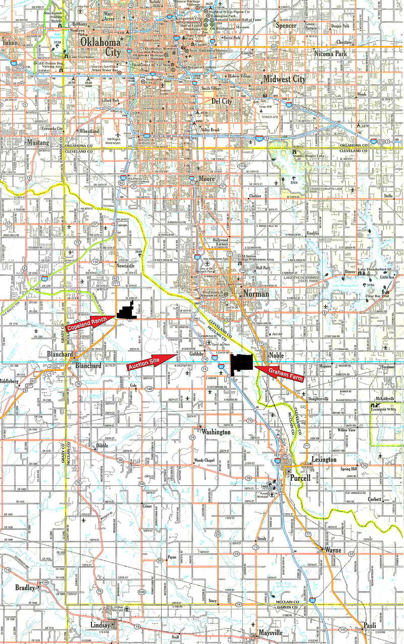
Newcastle, Oklahoma - McClain County, Oklahoma
Owner: South Canadian Land, LLC-Copeland Ranch
• 746+/- Acres offered in 13 Tracts from 15-208 Acres • Home Sites & Developmental • Part of the Famous Johnson Ranch • 1.5 Miles of Frontage on Hwy 9 • Intersection of Hwy 9 and US 62 • Land Never offered to the Public Until Now • Blanchard & Newcastle Schools • Online Bidding Available
OPEN HOUSE/INSPECTION DATES
May 17th from 1-4 PM
June 5th from 1-4 PM
June 19th from 2-4 PM
Meet a Schrader Representative on Tract 30 for land tours
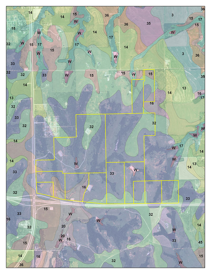
This is just a portion of the land to be auctioned that day. Please click here to view the other property located here
PROPERTY LOCATION
Take Exit 106 off I-35 and travel west on Hwy 9 for approximately 4 mile and the property will begin on your right.
AUCTION LOCATION
Southwind Hills, 468 SW 24th Ave., Goldsby, OK 73093
Take Exit 106 off Interstate 35 and travel west on Hwy 9 past the Riverwind Casino. After approximately 1 mile, turn left onto SW 24th Ave (Santa Fe Ave) and follow for approximately 2.6 miles and gated entrance will be on your right.
PROPERTY DESCRIPTION
The Copeland Ranch is located at the intersection of Hwy 9 and US 62, within the corporate limits of Newcastle, Oklahoma and approximately 4 miles west of Interstate 35 and the Riverwind Casino. 1.5+/- miles of the property fronts Hwy 9, which has a 17,000 average daily traffic count according to ODOT 2015 statistics. The west boundary of the ranch has approximately 2,000 feet of frontage on US 62, with an 11,900 average daily traffic count according to the same ODOT statistics. The ranch is comprised of generally rolling terrain, creating some terrific vistas and views of the Oklahoma City skyline. We will be offering the property in parcels ranging in size from 15 to 208 acres; with such diversity there are options in this sale for many different types of buyers. Bid on any individual parcel or combination of parcels that best fit you needs.
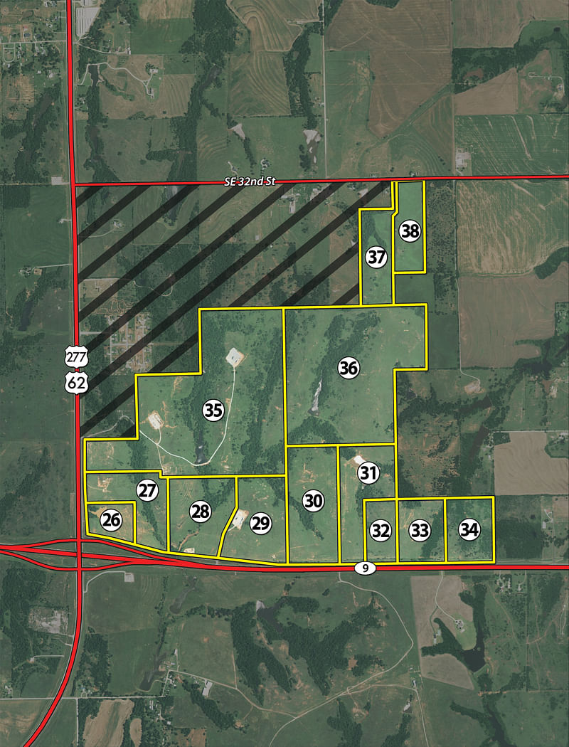
TRACT DESCRIPTIONS
Tract 26: 15± ac located at the intersection of Hwy 9 and Hwy 62, this parcel offers terrific future development potential and visibility.
Tract 27: 35± ac that surrounds Tract 26 and fronts both Hwy 9 and Hwy 62.
Tract 28: 45± ac with frontage on Hwy 9, a nice creek dissects this parcel creating an area for a terrific potential water feature or lake.
Tract 29: 45± ac with frontage along Hwy 9, great elevation and views of the surround landscape.
Tract 30: 62± ac fronting Hwy 9 and offering a mixture of open terrain and mature trees.
Tract 31: 48± ac fronting Hwy 9 and offering a mixture of open terrain, mature trees and an excellent watershed pond.
Tract 32: 20± ac fronting Hwy 9 with great elevation and views of the surrounding landscape.
Tract 33: 30± ac fronting Hwy 9 with great view to the north toward the Oklahoma City skyline.
Tract 34: 30± ac fronting Hwy 9 with a balance of mature trees and open pasture, this could make an excellent potential building site.
Tract 35: 208± ac along Hwy 62 with gently rolling terrain, mature trees and a fantastic pond in the center of the tract with plenty of places for additional water features.
Tract 36: 155± ac SWING TRACT with an excellent pond, open pasture of mature trees. Combine with surrounding parcels to create a package that best fits your needs.
Tract 37: 30± ac along SE 32nd Street on the north side of the property. This parcel has traditionally been used as a hay meadow, is very clean and would make a terrific potential building site.
Tract 38: 26± ac that offers a tremendous view toward the Oklahoma City skyline, terrific potential building site.
SOIL INFORMATION
PROCEDURE: Tracts 1 through 38 will be offered in individual tracts, in any combination of these tracts, or as a total unit per auction date and time. There will be open bidding on all tracts and combinations during the auctions as determined by the Auctioneer. Bids on tracts, tract combinations and the total property may compete. The property will be sold in the manner resulting in the highest total sale price.
MULTI-PROPERTY AUCTION: This brochure includes details on Tracts 26 through 38 of a multiple property auction that includes 38 total tracts. More details on Tracts 1 through 25 are available by visiting www.schraderauction.com or by calling 1-800-451-2709.
BUYERS PREMIUM: The contract purchase price will include a Buyers Premium equal to 4% of the bid amount.
DOWN PAYMENT: 10% of the total contract purchase price will be due as a down payment on the day of auction, with the balance due in cash at closing. The down payment may be made in the form of cashiers check, personal check, or corporate check. YOUR BIDDING IS NOT CONDITIONAL UPON FINANCING, SO BE SURE YOU HAVE ARRANGED FINANCING, IF NEEDED, AND ARE CAPABLE OF PAYING CASH AT CLOSING.
APPROVAL OF BID PRICES: All successful bidders will be required to enter into purchase agreements at the auction site immediately following the close of the auction. The auction bids are subject to the acceptance or rejection by the Seller.
DEED: Seller shall be obligated to convey a merchantable title by Warranty Deed.
EVIDENCE OF TITLE: Seller agrees to make available to bidder a preliminary title insurance commitment to review prior to auction. The cost of title insurance, if the buyer(s) elects to purchase the title insurance policy, will be the responsibility of the buyer(s). Seller agrees to provide merchantable title to the property subject to matters of record, general conditions of title, and similar related matters. All tracts sold AS-IS.
CLOSING: The closing shall take place 45 days after the auction, or as soon thereafter as any necessary surveys are conducted and applicable closing documents are completed by Seller.
POSSESSION: Possession of the land shall be at closing, subject to rights of current tenants. Tracts 18, 20, 21, 22 and 23 are subject to a farm lease that expires at harvest of existing 2017 crops. Tract 19 is subject to a farm lease that expires June 30th, 2017. Tracts 26 through 38 are subject to a pasture lease that expires December 31st, 2017.
REAL ESTATE TAXES: Real Estate taxes shall be prorated to the date of closing.
MINERALS: Seller will not specifically except or reserve any mineral rights, however; the Seller, Auction Company or its agents make no representation or warranty to the extent of mineral ownership, if any, held by Seller. SURVEY: The Seller shall provide a new survey where there is no existing legal description or where new boundaries are created by the tract divisions in this auction. Any need for a new survey shall be determined solely by the Seller. Seller and successful bidder shall each pay half (50:50) of the cost of the survey. The type of survey performed shall be at the Sellers option and sufficient for providing title insurance. Closing prices shall be adjusted to reflect any difference between advertised and surveyed acres, if a new survey is determined to be necessary by the Seller.
ACREAGE AND TRACTS: All acreages are approximate and have been estimated based on current legal descriptions and/or aerial photos. Any corrections, additions, or deletions will be made known prior to the auction.
AGENCY: Schrader Real Estate and Auction Company, Inc. and their representatives are exclusive agents of the Seller.
DISCLAIMER AND ABSENCE OF WARRANTIES: All information contained in this brochure and all related materials are subject to the terms and conditions outlined in the Purchase Agreement. The property is being sold on an AS IS, WHERE IS basis, and no warranty or representation, either expressed or implied, concerning the property is made by the Seller or the Auction Company. All sketches and dimensions in the brochure are approximate. Each potential bidder is responsible for conducting his or her own independent inspections, investigations, inquiries, and due diligence concerning the property. The information contained in this brochure is subject to verification by all parties relying on it. No liability for its accuracy, errors, or omissions is assumed by the Seller or the Auction Company. Conduct of the auction and increments of bidding are at the direction and discretion of the Auctioneer. The Seller and Selling Agents reserve the right to preclude any person from bidding if there is any question as to the persons credentials, fitness, etc. All decisions of the Auctioneer are final. ANY ANNOUNCEMENTS MADE THE DAY OF THE SALE TAKE PRECEDENCE OVER PRINTED MATERIAL OR ANY OTHER ORAL STATEMENTS MADE.
NEW DATE, CORRECTIONS AND CHANGES: Please arrive prior to scheduled auction time to inspect any changes or additions to the property information.
OWNER: South Canadian Land
BRENT WELLINGS
(405) 332-5505
(972) 768-5165 (cell)
Email Agent

Download the PDF or Mail me this brochure
Email this information to a friend


