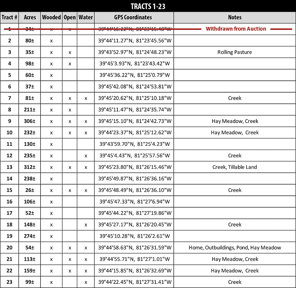
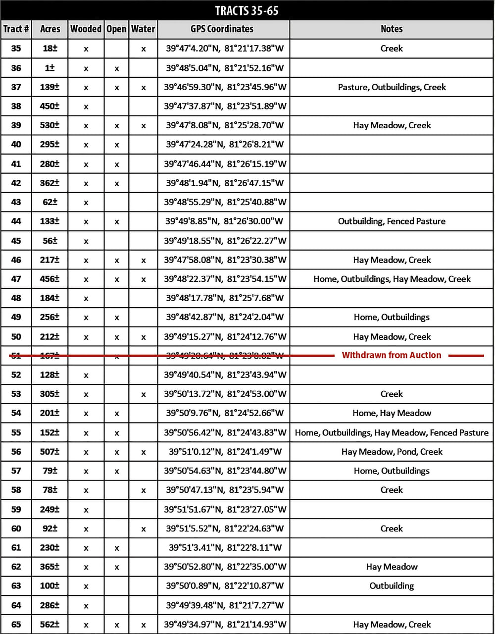
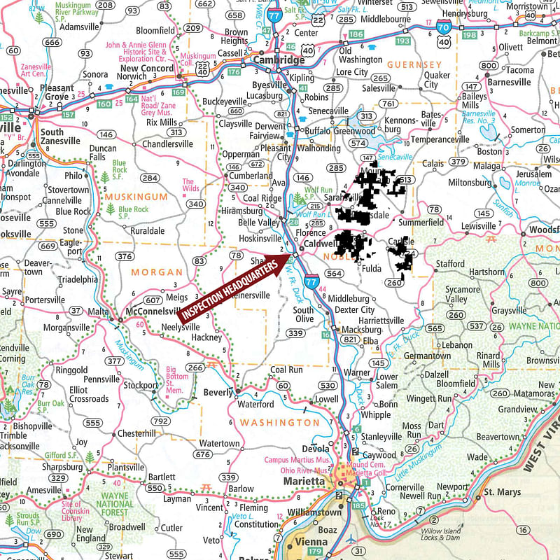
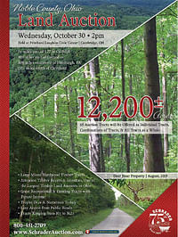
LAND AUCTION - 12,200+/- ACRES OFFERED IN 65 TRACTS IN NOBLE COUNTY, OHIO
Wed, Oct 30, 2:00 PM
Noble County, Ohio
Owner: CNX Land, LLC
• 12,200+/- Acres in 65 Tracts • 65 Auction Tracts will be offered as Individual Tracts, Combinations of Tracts & All Tracts as a Whole • Large Mixed Hardwood Timber Tracts • Attention Timber Buyers & Investors, One of the Largest Timberland Auctions in Ohio • Great Recreational & Hunting Tracts with Future Income • Trophy Deer & Numerous Turkey • A Rare Investment Opportunity • Easy Access from Public Roads • Tracts Ranging from 10+/- to 562+/- • 5+/- miles East of I-77 in Caldwell • 80+/- miles east of Columbus • 80+/- miles southeast of Pittsburgh, PA • 110+/- miles south of Cleveland • This auction represents one of the largest timberland offerings sold at auction in Ohio. Excellent young stock of hardwood trees and productive soils. Great roads and frontage. Tracts range in size from 10+/- to 562+/- acres. You may bid on any tract or combination of tracts that suit your needs! This is a wonderful opportunity to bid your price! • Minerals will be excluded from the sale • ONLINE BIDDING AVAILABLE You may bid online during the auction at www.schraderauction.com. You must be registered One Week in Advance of the Auction to bid online. For online bidding information, call Schrader Auction Company at 800-451-2709. • Lender info: For knowledgeable lending about this property contact ![]() Rural 1st Farm Credit, James D Cline - Sr Consumer Loan Officer - NMLS ID# 456787 - james.cllne@rural1st com - T: 740.439.7971 C: 740.630.1804 - 8971 Whitaker Road, Cambridge, OH
Rural 1st Farm Credit, James D Cline - Sr Consumer Loan Officer - NMLS ID# 456787 - james.cllne@rural1st com - T: 740.439.7971 C: 740.630.1804 - 8971 Whitaker Road, Cambridge, OH
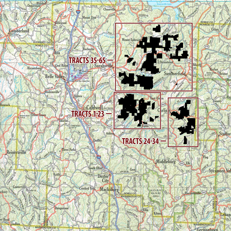
OPEN HOUSE/INSPECTION DATES
Comfort Inn and Suites - 44380 West Hills Lane, Caldwell, OH 43724
Located in the northwest corner of the intersection of I-77 (exit 25) and OH-78. Travel west on OH-78 1/4 mile to W Hills Lane. Turn north on W Hills Lane toward the hotel.
Meet a Schrader Representative at the inspection headquarters for more information about the auction:
Thursday, September 12 from 3-6pm
Friday, September 13 from 9am-Noon
Friday, October 4 from 3-6pm
Saturday October 5 from 9am-Noon
Thursday, October 17 from 3-6pm
Friday, October 18 from 9am-Noon
**ADDED ADDITIONAL DATE:****
Tuesday, October 29 from 5-7pm
Contact Auction Company for Detailed Information Booklets with additional Due-Diligence Materials, including: soil maps, topographic maps, and county tax information.
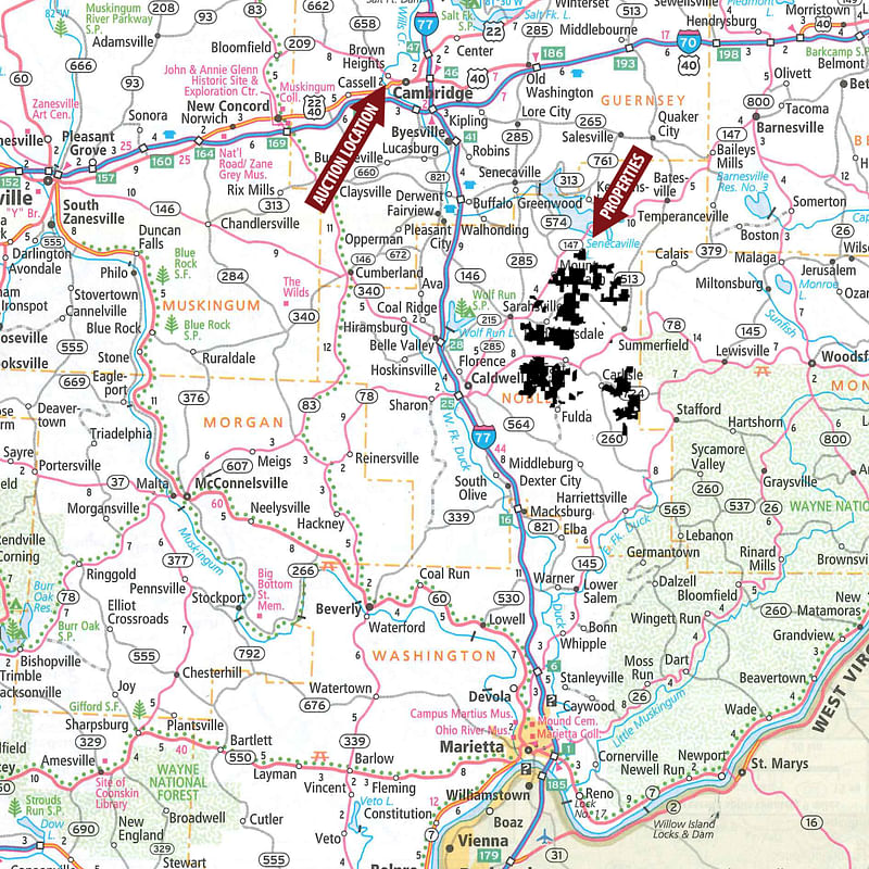
PROPERTY LOCATION
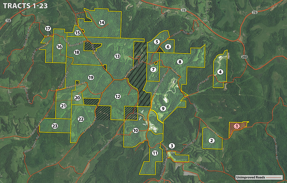
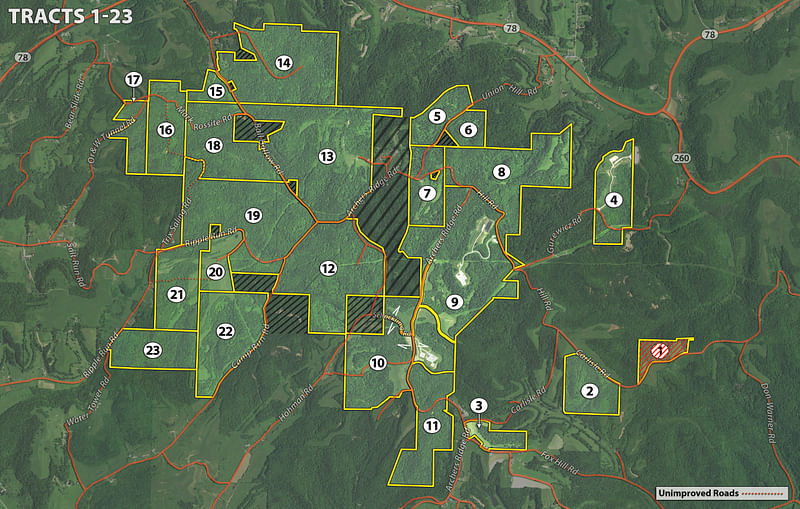
Directions to Tracts 1-23: From the Intersection of Hwy 78 and Hwy 821 in Caldwell, OH., travel east on Hwy 78 for approx. 5.1 miles to Ball Hallow Rd. Turn right on Ball Hallow Rd and travel approx. 0.7 miles to Tract 14 on the left side of the road.
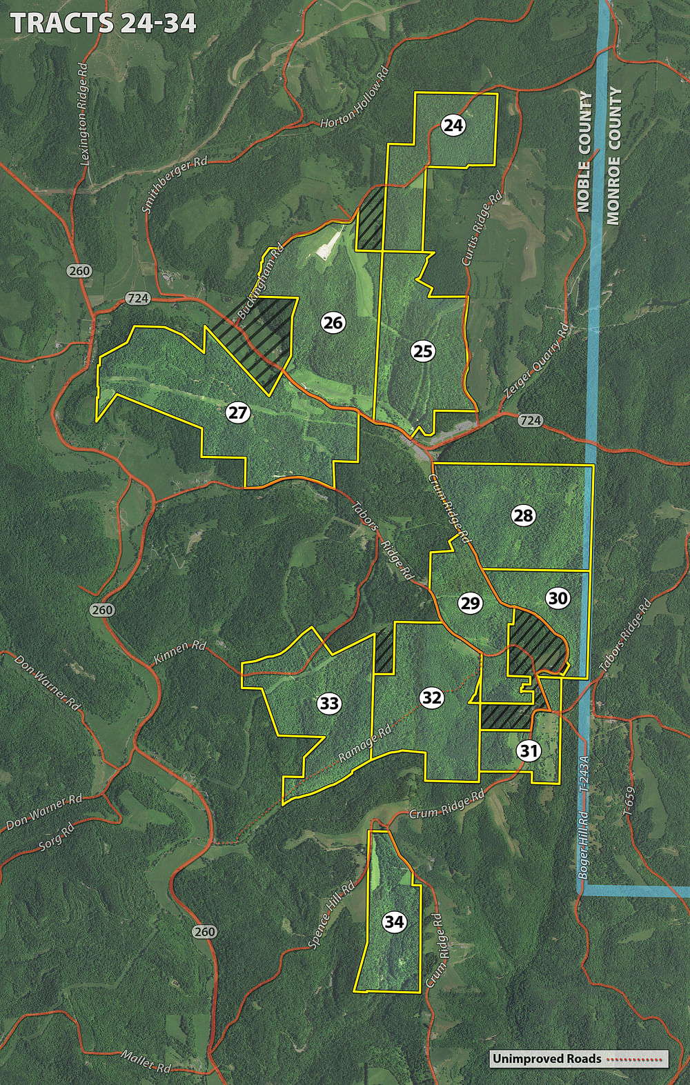
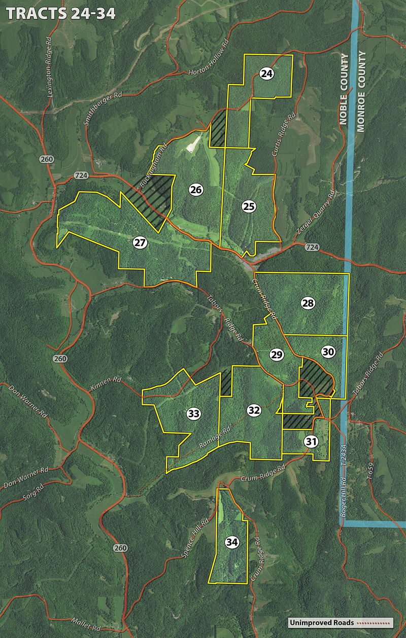
Directions to Tracts 24-34: From the Intersection of Hwy 78 and Hwy 821 in Caldwell, OH, travel east on Hwy 78 for approx. 8.8 mi to Road Fork Rd. Turn right on Road Fork Rd and travel approx. 2.2 mi to Pump Station Rd. Turn left on Pump Station road and travel approx. 1.2 miles to Tract 26 on the left side of the road.
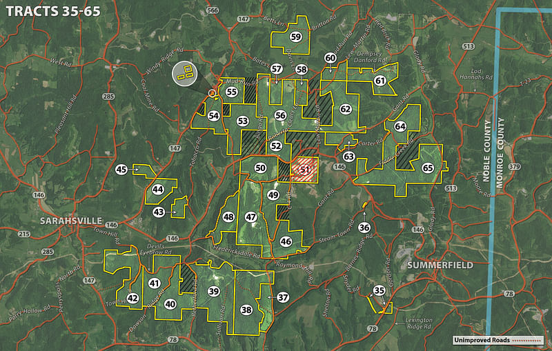
Directions to Tracts 35-65: From the intersection of Monroe St and Seneca Lake Rd in Sarahsville, OH travel east on Seneca Lake Rd approx. 0.9 miles to Zep Rd. Turn right on Zep Rd and travel approx. 3.3 miles to Tract 50 on the right side of the road.
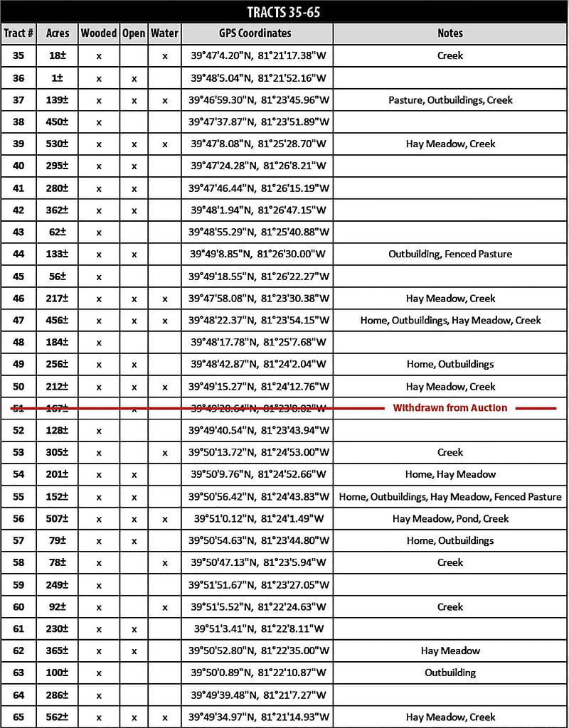
AUCTION LOCATION
Pritchard Laughlin Civic Center, 7033 Glenn Hwy, Cambridge, OH 43725
From the Interchange of I-70 and I-77 in Cambridge OH, Travel West on I-70 approx. 3.2 miles to Exit 176. Take Exit 176 toward US 22/Glenn Hwy. Turn right on US 22/Glenn Hwy and travel approx. 0.9 miles to Pritchard Laughlin Civic Center on the left side of the road.
PROPERTY DESCRIPTION
*** Coal Lease Summary: ***

PROCEDURE: 65 auction tracts will be offered as individual tracts, any combination of tracts and all tracts as a whole. There will be open bidding on all tracts and combinations during the auction as determined by the Auctioneer.
DOWN PAYMENT: 10% down payment on the day of auction. The down payment may be made in the form of cashiers check, personal check, or corporate check. YOUR BIDDING IS NOT CONDITIONAL UPON FINANCING, so be sure you have arranged financing, if needed, and are capable of paying cash at closing.
BUYERS PREMIUM: A 7% Buyers Premium will be added to the final bid price and included in the contract purchase price.
ACCEPTANCE OF BID PRICES: All successful bidders will be required to sign Purchase Agreements at the auction site immediately following the close of the auction. All final bid prices are subject to the Sellers acceptance or rejection.
EVIDENCE OF TITLE: After the Auction and prior to closing, Seller shall furnish updated title evidence consisting of an updated certificate of title or title insurance commitment disclosing marketable title to the Purchased Tracts, subject to all standard requirements, conditions and exceptions and subject to the Permitted Exceptions. If Buyer and/or Buyers lender elect(s) to purchase title insurance, the premiums for issuing the owners and/or lenders title insurance policy shall be charged to Buyer.
DEED: Seller shall provide Limited Warranty Deed(s). Minerals will be excluded from the sale. Grantor further reserves all rights to use and occupy the surface of the land conveyed to the extent necessary, convenient or incidental to the possession, enjoyment, exploration, development, operation, maintenance, transportation, or production of or from the oil, gas, coal and other minerals of any kind or character within and underlying said property or other properties.
CLOSING: The balance of the real estate purchase price is due at closing, which will be approx. 45 days after the auction.
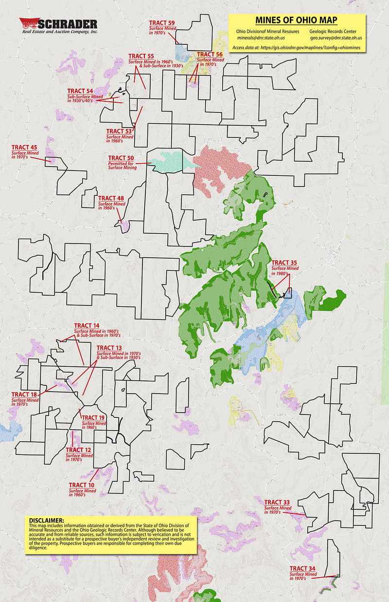
POSSESSION: Possession is at closing, subject to a coal lease on part or all of tracts 26-33, 43, 44, 47- 50, 52-58, and 60-65.
REAL ESTATE TAXES: Real estate taxes will be prorated on a calendar year basis to the date of closing.
PROPERTY INSPECTION: Each potential Bidder is responsible for conducting, at their own risk, their own independent inspections, investigations, inquiries and due diligence concerning the property. Inspection dates have been scheduled and will be staffed with auction personnel. Seller and Auction Company disclaim any and all responsibility for the safety of Bidders during any physical inspection of the property. No person shall be deemed an invitee of the property by virtue of the offering of the property for sale.
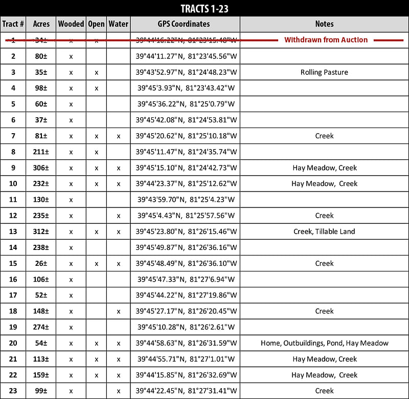
ACRES & BOUNDARIES: Advertised acres are approximate and have been estimated based on tax parcel &/or GIS data and an approximate, provisional allocation between potential new tracts. Boundary lines and tract maps are approximations provided for general identification and illustration purposes. They are not intended to depict or establish authoritative boundaries or locations.
SURVEY: The Seller shall provide a new survey where there is no existing legal description or where new boundaries are created by the tract divisions in this auction. Any need for a new survey shall be determined solely by the Seller. Seller and successful bidder shall each pay half (50:50) of the cost of the survey. The type of survey will be determined by Seller and will be sufficient for recording the conveyance. Combination purchases will receive a perimeter survey only.
AGENCY: Schrader Real Estate & Auction Company, Inc. and its representatives are exclusively the agents of the Seller.
DISCLAIMER AND ABSENCE OF WARRANTIES: All information contained in this brochure and all related materials are subject to the terms and conditions outlined in the Purchase Agreement. The property is being sold on an AS IS, WHERE IS basis, and no warranty or representation, either expressed or implied, concerning the property is made by the Seller or the Auction Company. All sketches and dimensions in the brochure are approximate. Each potential bidder is responsible for conducting his or her own independent inspections, investigations, inquiries, and due diligence concerning the property. The information contained in this brochure is subject to verification by all parties relying on it. No liability for its accuracy, errors, or omissions is assumed by the Seller or the Auction Company. Conduct of the auction and increments of bidding are at the direction and discretion of the Auctioneer. The Seller and Selling Agents reserve the right to preclude any person from bidding if there is any question as to the persons credentials, fitness, etc. All decisions of the Auctioneer are final.
ANY ANNOUNCEMENTS MADE THE DAY OF THE SALE TAKE PRECEDENCE OVER PRINTED MATERIAL OR ANY OTHER ORAL STATEMENTS MADE.
RD SCHRADER, CAI
(800) 451-2709
Email Agent
Download the PDF or Mail me this brochure
Email this information to a friend