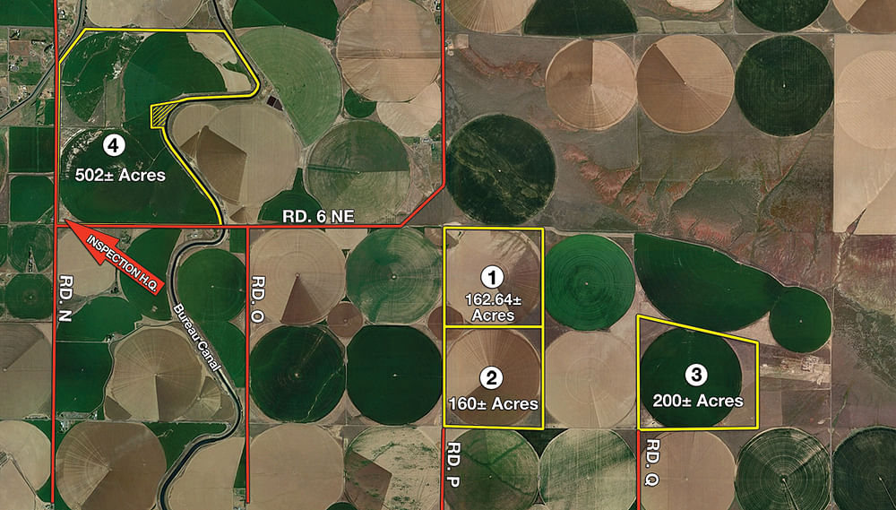
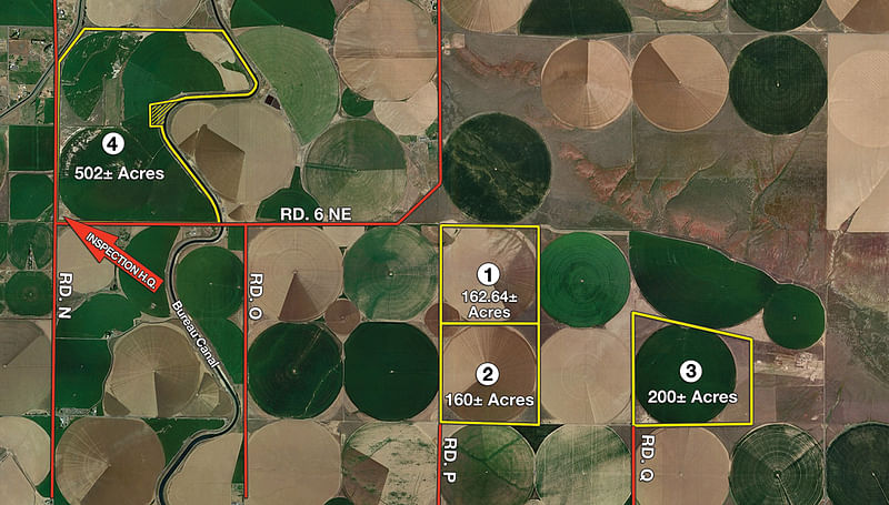
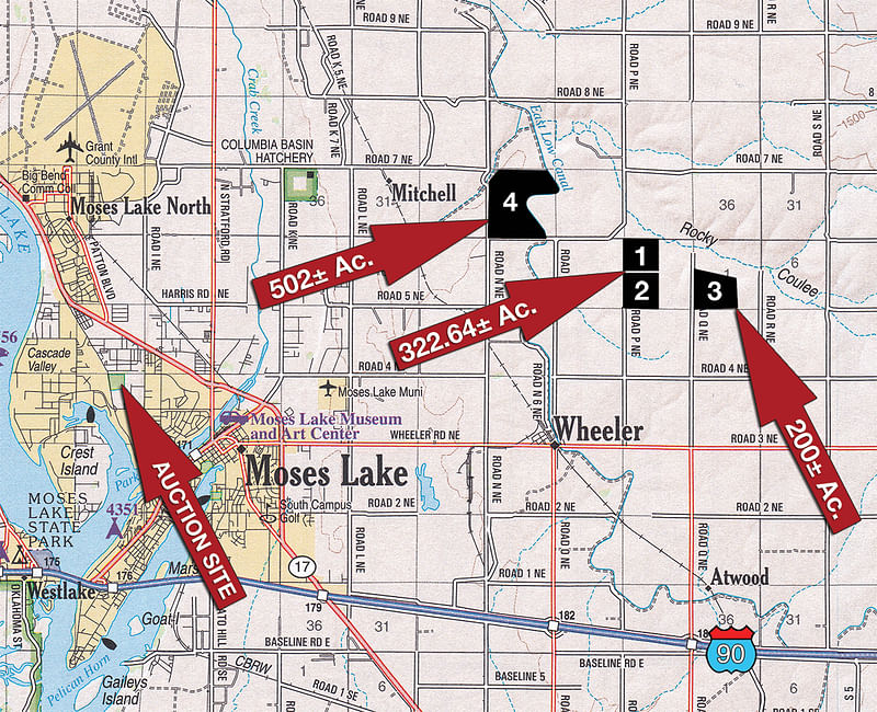
LAND AUCTION - 1025+/- ACRES OFFERED IN 4 TRACTS IN GRANT COUNTY, WASHINGTON
Thu, Mar 24, 2:00 PM
Moses Lake, Washington - Grant County
Owner: Ron & Robin Fode - Due to family health reasons, the Fodes have decided to sell their Large Acreage, Irrigated, Deep Loamy Soil Farm at Multi-Parcel Auction.
• 1,025+/- Gross Acres • 775+/- Irrigated Acres • Deep Loamy Soils • 4 Tracts Ranging from 160+/- to 502+/- Acres • Long Term Rotating Potato Lease in Place • All Tracts with 5 Miles of Each Other • All Dirt / No Outbuildings • Soil Map with Slopes available in buyers packet or yarbro.com • Contact Auction Company for Water Line Maps • Located just 8+/- Miles Northeast of Moses Lake • Bid on your choice of Tracts, Combinations of Tracts or the Entire 1,025+/- Acres of Productive Farmland!
OPEN HOUSE/INSPECTION DATES
PREVIEW TIMES: Meet a Yarbro/Schrader Representative for more information on the following dates:
March 7th from 1pm-5pm
March 10th from 10am-3pm
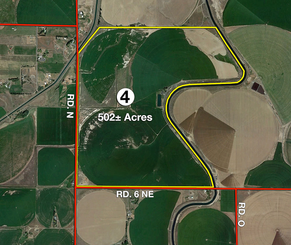
Meet at the Corner of Road N NE & 6NE (SW Corner of Tract 4) Look for Chuck Yarbro Auctioneers Office Trailer as Inspection Headquarters.
PROPERTY LOCATION
Tract 1 Directions: From the corner of Wheeler Road & O NE (East of Bridge & East Low Canal) drive North on Road O NE 3 miles to 6NE. Turn East & drive 1 mile to Tract 1. Veer right on gravel road. Watch for Auction Signs. To access Tract 1 from the corner of N NE & 6NE drive 2 miles & follow the directions from above.
Tract 2 Directions: From the Corner of Wheeler Road/3NE turn North on Road PNE & drive 2 miles to SW corner of Tract 2 which is the corner of PNE & 5NE. Please note-To access Tract 1, continue north on PNE. Watch for auction signs.
Tract 3 Directions: from Corner of Wheeler/3NE Road & Road QNE drive north 2 miles to SW corner of Tract 4. Watch for Auction Signs - Please note to access Tract 6 drive West on 5NE 1 Mile to Southwest Corner of Tract 2.
Tract 4 Directions: Corner of Wheeler Road & N NE Drive North 3 miles Road 6NE. SW Corner of Tract 3 is located on the corner of N NE & 6NE. To access Tract 3 from Tract 1, drive 2 miles to Tract 3 on North side of road. Watch for Auction Signs.
AUCTION LOCATION
Grant Co. Fairgrounds 4-H Bldg.
From I-90 & WA-17N (Exit 179): Drive north on WA-17N for 1.5 miles then vear right and continue on WA-17N for 6.3 more miles. Turn left onto Airway Drive (Conoco Fuel Station on corner). Travel 1.5 miles to the Grant County Fairgrounds. Watch for auction signs to the 4-H Building.
Address: 3953 Airway Dr NE, Moses Lake, WA 98837
TRACT DESCRIPTIONS
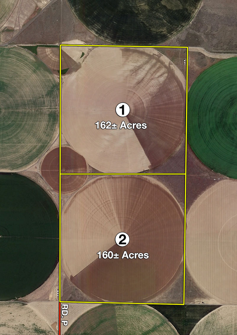
Tract 1: 162.6± ac Gross Acres*; 151+/- Irrigated Acres**; Soils - Sage Hill Very Fine Sandy Loam & Warden Silt Loam; Last 5-year crop rotation have been Potatoes, Hay, Wheat; Valley 9, 4 & 2 Tower Pivots irrigates this tract. Water provided by irrigation wells and shared water lines. Existing rotating potato lease for 2018 and 2022.
Tract 2: 160± ac Gross Acres*; 159+/- Irrigated Acres**; Soils - Warden Silt Loam & Shano Silt Loam; Last 5-year crop rotation have been Potatoes, Hay, Wheat; Valley 8 Tower Pivot irrigates this Tract. Bureau Water via shared water lines. Existing rotating potato lease for 2019 and 2023.
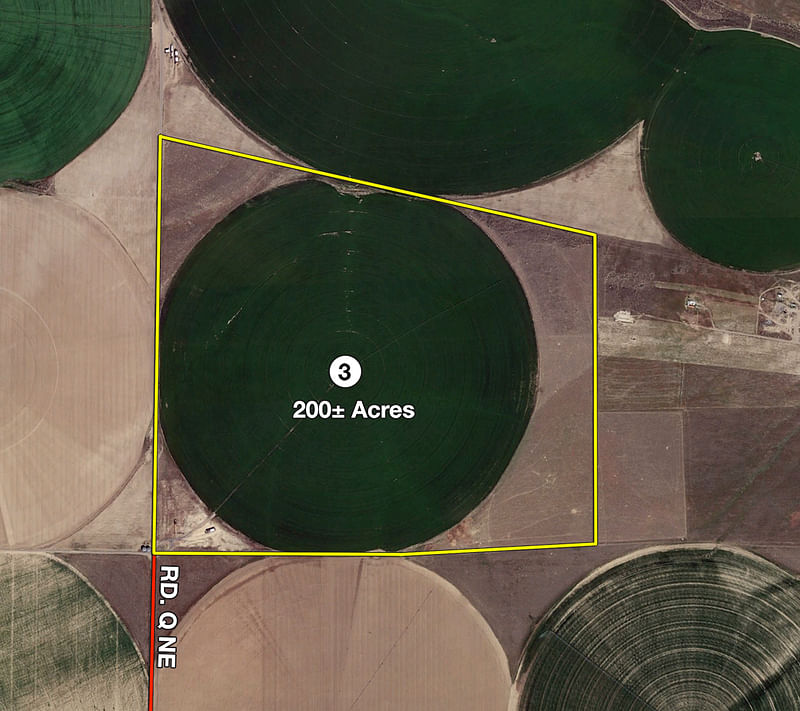
Tract 3: 200± ac Gross Acres*; 135+/- Tillable Acres**; Soils - Sage Hill Very Fine Sandy Loam, Warden Silt Loam, Shano Silt Loam & Ephrata Fine Sandy Loam; Last 5-year crop rotation have been Potatoes, Hay, Wheat. Existing rotating potato lease for 2016, 2020 and 2024.
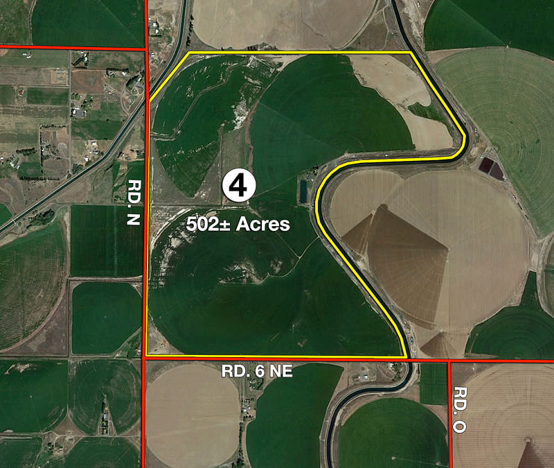
Tract 4: 502± ac Gross Acres*; 465+/- Irrigated Acres**; Soils - All Loamy Soils with varying from Very Fine Sandy Loam to Fine Sandy Loam. Slope from level to variations of 2%-5%. Some-slope runs up to 10%-15%; Last 5 year crop rotation has been Potatoes, Hay, Wheat & Corn; Zimmatic 11,7, & 6 Tower Pivots, Valley 8 & 5 Tower Pivots & Sargent (Aluminum Pipe) 4 Tower Pivots irrigate this Tract. Bureau Water. Various portions of the property are leased in rotation through 2024. Contact Auction Company for rotation schedule/map.
*per Grant County Assessor **Estimated from third party maps and farm GPS.
For more information on shared water lines and existing leases, contact Auction Company.
BUREAU WATER
Bureau water used in the irrigated portions of the auction property is part of a reservoir system starting at Grand Coulee Dam which provides reliable surface water to the area via canals. Water is managed through the East Columbia Basin Irrigation District.
PROCEDURE: The property will be offered in 4 individual tracts, any combination of tracts and as a total 1,025+/- acre unit. There will be open bidding on tracts, combinations, and the entire property during the auction as determined by the auctioneer. Bids on the tracts and combinations may compete.
AUCTION CONDUCT: Conduct of the auction and increments of bidding are at the sole discretion of the Auctioneer. The Seller and Selling Agents reserve the right to preclude any person from bidding if there is any question as to the persons credentials, fitness, etc. All decisions of the Auctioneer are final.
BUYERS PREMIUM: A Buyers Premium in the amount of 4% of the bid amount shall be charged to the Buyer.
EARNEST MONEY: 20% of the accepted contract price is due as earnest money at the close of the auction. If the bidder pre-registers with the Auction company on or before Friday, March 18, 2016 then cash, personal or corporate check will be accepted for the down payment (contact Auction company for a pre-registration form or visit www.yarbro.com). If the bidder does not pre-register, a bank letter of credit or guarantee will be required with a personal check, OR bidder must present a $25,000 cashiers check with a personal check for the balance of the down payment on auction day. YOUR BIDDING IS NOT CONDITIONAL UPON FINANCING, SO BE SURE YOU HAVE ARRANGED FINANCING, IF NEEDED, AND ARE CAPABLE OF PAYING CASH AT CLOSING.
ACCEPTANCE OF BID PRICES: The successful bidder(s) will sign a Purchase Agreement at the conclusion of the auction. The Agreement(s) are subject to an existing first right of refusal. Contact Auction company for details.
EVIDENCE OF TITLE: The Seller will provide a preliminary title opinion, certificate, or report to be made available to prospective bidders for review prior to bidding. Seller agrees to furnish at Sellers expense an Owners Policy of Title Insurance in the amount of the purchase price. Seller will convey title free and clear of liens, but otherwise subject to all easements and matters of record. All tracts sold AS IS.
DEED: Warranty deed(s) will be delivered at closing.
CLOSING: Closing will take place on April 25, 2016, or as soon thereafter as Sellers closing documents are completed.
POSSESSION: Possession shall be at closing subject to the existing farm lease and Sellers right to the first cutting of hay where planted. Contact the Auction company for more information.
REAL ESTATE TAXES: Real estate taxes will be prorated to the day of closing.
TRACT MAP ACRES: Tract maps, depicted boundaries, and stated acres are approximates based on county parcel data, current legal descriptions, and/or aerial mapping software and are not provided as survey products.
SURVEY: It is expected that the current legal descriptions will be sufficient to convey the property. Any need for a new survey will be determined by the Seller. If a new survey is required, the survey costs will be shared equally between the Buyer and Seller. The type of survey provided will be at the Sellers option. Combination purchases only receive a perimeter survey.
AGENCY: Chuck Yarbro Auctioneers and its agents and representatives are exclusively the agents of the Seller.
DISCLAIMER AND ABSENCE OF WARRANTIES: All information contained in this brochure and all related materials are subject to the terms and conditions outlined in the Purchase Agreement. The property is being sold on an AS IS, WHERE IS basis, and no warranty or representation, either express or implied, concerning the property is made by the Seller or the Auction Company. All sketches and dimensions in the brochure are approximate. Each potential bidder is responsible for conducting his or her own independent inspections, investigations, inquiries, and due diligence concerning the property. The information contained in this brochure is subject to verification by all parties relying on it. No liability for its accuracy, errors, or omissions is assumed by the Seller or the Auction Company.
STOCK PHOTOGRAPHY: Some photos are for illustrative purposes only and are not of the auction property.
ANY ANNOUNCEMENTS MADE THE DAY OF THE AUCTION TAKE PRECEDENCE OVER PRINTED MATERIAL OR ANY OTHER ORAL STATEMENTS MADE.
CHUCK YARBRO JR
(509) 765-6869
(509) 760-3789 (cell)
Email Agent

Download the PDF or Mail me this brochure
Email this information to a friend