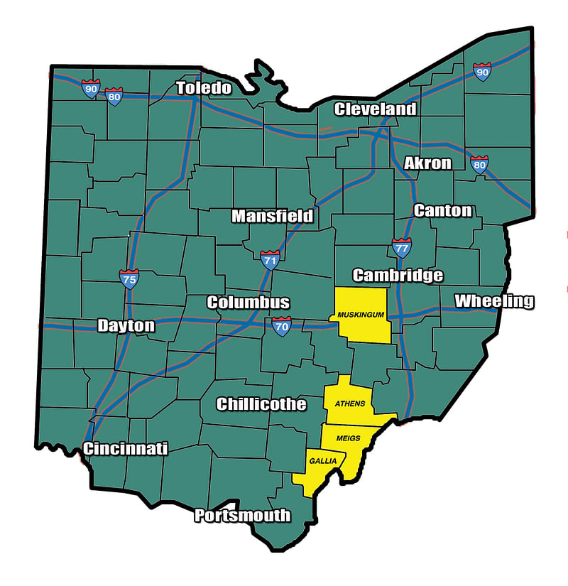
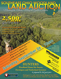
WOODLAND AUCTION, SOUTHEAST OHIO WOODLAND - 2,500+/- Acres offered in 66 Tracts in Muskingum, Athens, Meigs & Gallia Counties
Sat, Sep 26, 10:00 AM
Southeast Ohio Woodland, Muskingum, Athens, Meigs & Gallia Counties
Owner: Ohio Franklin Realty, LLC
• 2,500+/- Acres offered in 66 Tracts • Excellent Deer Hunting • Trophy Deer & Turkey Hunting • Woodland Acreage • Timber Production Income • Many of these tracts have excellent interior road/trail systems for easy access to hunting & recreation. • 516 Acres in Muskigum Co. • 878 Acres in Athens Co. • 1,040 Acres in Meigs Co. • 71 Acres in Gallia Co. • Hunters, Woodland Home Site Buyers, Developers & Timberland Investors be prepared to bid your price. • Muskingum Co. ranks 2nd in Buckeye Big Buck Club (BBBC) and 3rd in overall turkey harvest. Athens Co. ranks 5th in BBBC.
OPEN HOUSE/INSPECTION DATES
Wednesday, August 26 from 3 to 6 pm
Thursday, September 10 from 3 to 6 pm
FOR TRACTS 30-38 ONLY
Meet an auction representative at - Tract 31.
ALL OTHER TRACTS
Meet an auction representative at - the Athens Community Center
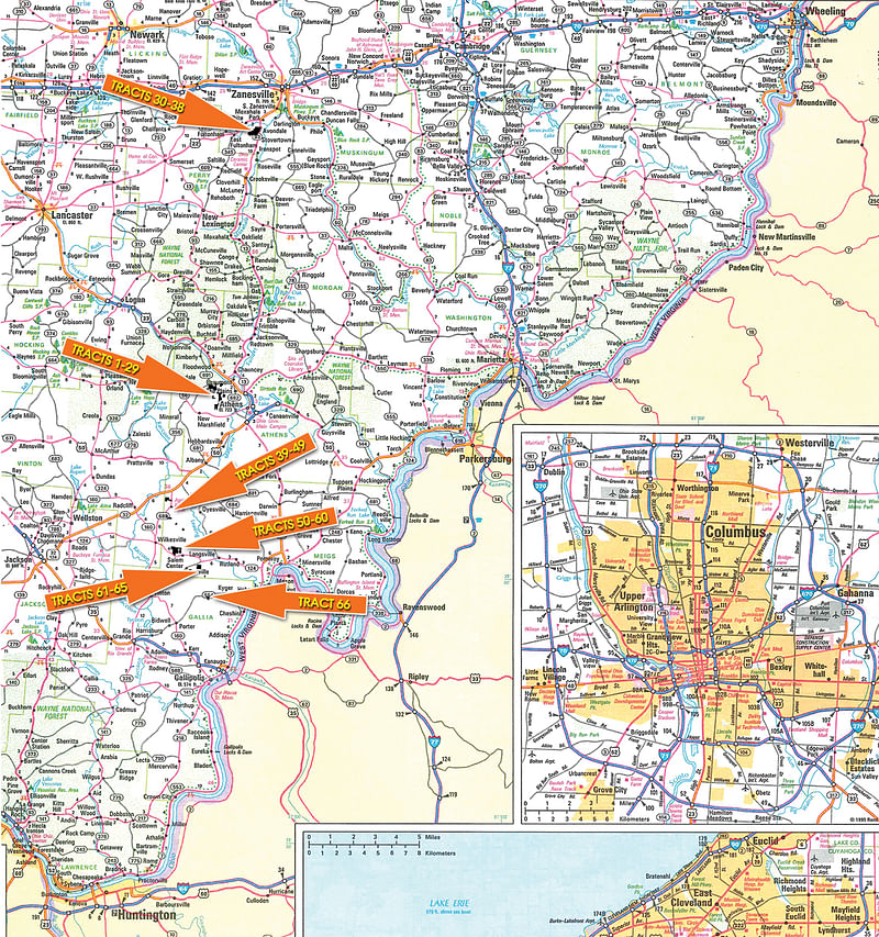
PROPERTY LOCATION
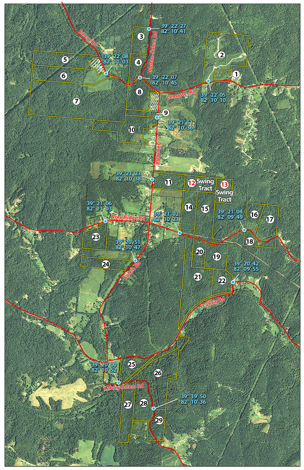
ATHENS COUNTY - TRACTS 1-29
Tracts 1-2: Exit US 33 at The Plains go south 0.25 mile on SR 682, turn right on Poston Rd, go 2.5 miles, turn left on Poston Salem Rd and proceed 0.75 mile turn left on Salem Rd. go 0.25 mile turn left on Lemaster Rd. go 0.5 mile to tracts 1-2.
Tracts 3, 4 & 8: From the intersection of Poston Rd & Poston-Salem Rd, take Poston-Salem Rd south and proceed 0.5 mile to tracts 3, 4 & 8.
Tracts 5-7: From the intersection of Poston Rd & Poston-Salem Rd, take Poston-Salem Rd south and proceed 0.75 mile turn right on Salem Rd. go 0.25 mile to tracts 5-7.
Tracts 9-10: From the intersection of Poston Rd & Poston-Salem Rd, take Poston-Salem Rd south and proceed 0.75mile turn left on Salem Rd. go 0.5 mile to tract 9-10.
Tracts 11-13: From the intersection of Poston Rd & Poston-Salem Rd, take Poston-Salem Rd south and proceed 0.75 mile turn left on Salem Rd. go 0.75 mile to tracts 11-13.
Tracts 14-21: From the intersection of Poston Rd & Poston-Salem Rd, take Poston-Salem Rd south and proceed 0.75 mile turn left on Salem Rd. go 1.25 miles turn left on Vore Ridge Rd. go 0.25 mile to tracts 14, 15 & 19-21. Continue approx. 0.25 mile to tracts 16-18.
Tract 22: From the intersection of Poston Rd & Poston-Salem Rd, take Poston-Salem Rd south and proceed 0.75 mile turn left on Salem Rd. go 2.5 miles turn left on Luhrig Rd. go 1.25 miles to tract 22.
Tract 23: From the intersection of Poston Rd & Poston-Salem Rd, take Poston-Salem Rd south and proceed 0.75 mile turn left on Salem Rd. go 1.25 miles turn right on Vore Ridge Rd. go 0.25 mile to tract 23.
Tract 24: From the intersection of Poston Rd & Poston-Salem Rd, take Poston-Salem Rd south and proceed 0.75 mile turn left on Salem Rd. go 1.5 miles to tract 24.
Tracts 25-29: From the intersection of Poston Rd & Poston-Salem Rd, take Poston-Salem Rd south and proceed 0.75 mile turn left on Salem Rd. go 3 miles to tracts 25-29.
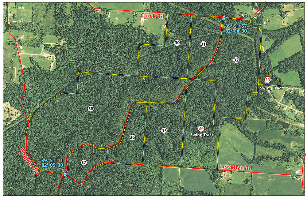
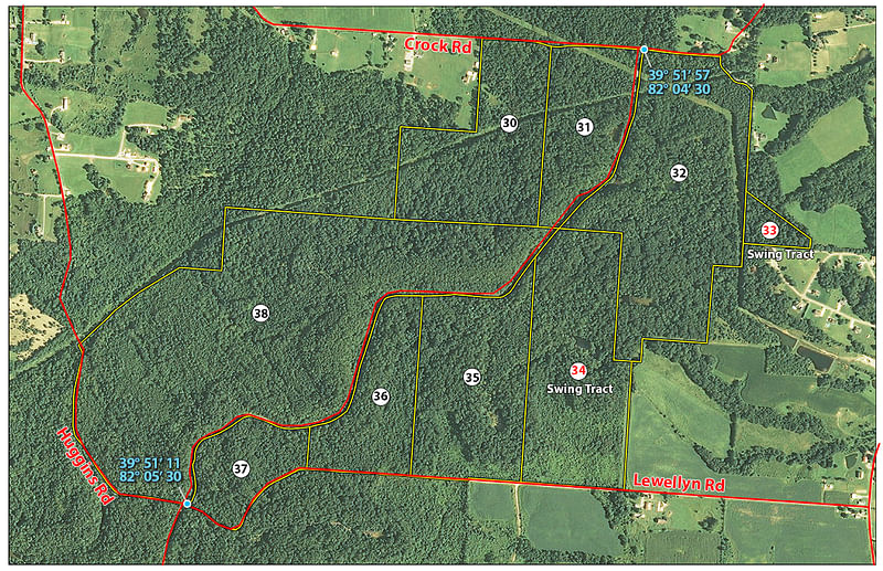
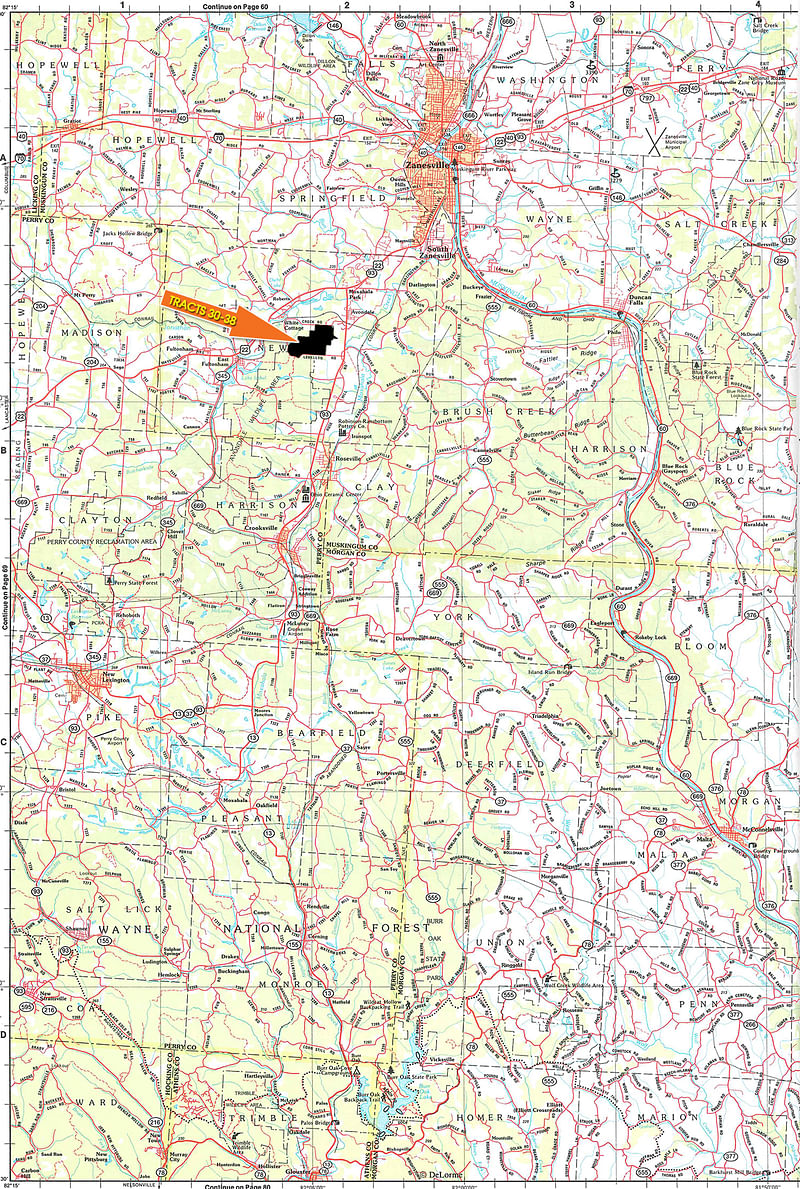
MUSKINGUM COUNTY - TRACTS 30-38
Tracts 30-38: From Zanesville pick SR-22 (Maysville Pike) south. Travel approximately 2.5 miles and there will be a large Shopping Center on left (Kmart, Walmart, Bob Evans, etc.) continuing south on SR-22 approximately 1.5 miles and turn left onto SR 93 south. Travel approximately 0.8 mile and Crock Rd will be on right. Turn right onto Crock Rd. and travel 0.6 mile and signs will be posted for tracts 30-32. To view tracts 34-38 traveling south on SR -93 past Crock Rd. 0.6 mile to Heckel Rd. Turn right on Heckel (Heckel is a loop road and has two access points to SR-93.) and follow Heckel up to Lewellyn Rd. and turn right. Travel Lewellyn Rd. approximately 0.5 miles and the tracts will be posted on the right side of the road.
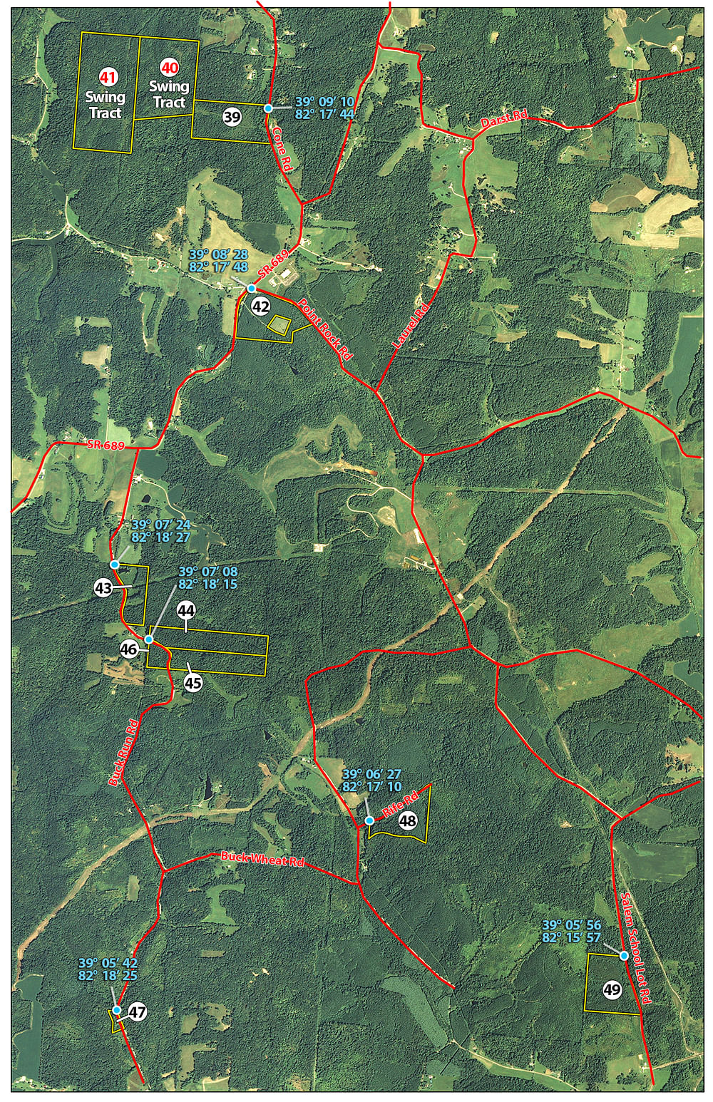
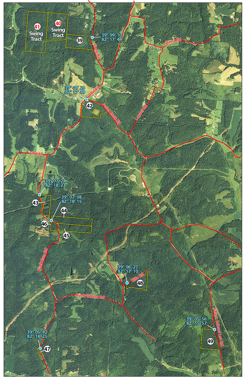
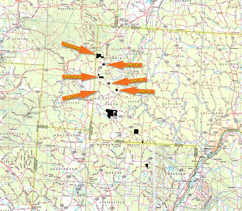
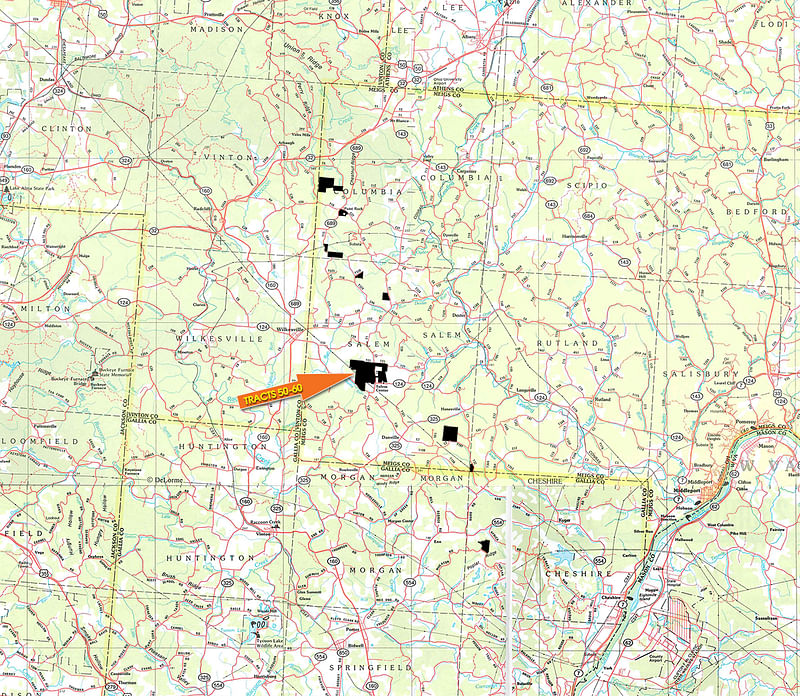
MEIGS/GALLIA COUNTY - TRACTS 39-66
Tracts 39-41: From the intersection of SR 32 and SR 689 take SR 689 south approximately 2.3 miles to Cone Road. Turn right on Cone Road go 0.3 miles to property on left.
Tract 42: From the intersection of SR 32 and SR 689 take SR 689 south approximately 2.8 miles to Castor Cemetery Road. Property is located on both sides of Castor Cemetery Road.
Tract 43: From the intersection of SR 32 and SR 689 take SR 689 south approximately 3.6 miles to Buck Run Road. Turn left and go 0.5 miles to property on the left.
Tract 44-46: From the intersection of SR 32 and SR 689 take SR 689 south approximately 3.6 miles to Buck Run Road. Turn left and go approximately 0.9 miles to the property on left and right.
Tract 47: From the intersection of SR 32 and SR 689 take SR 689 south approximately 3.6 miles to Buck Run Road. Turn left and go approximately 2.8 miles to property on the right.
Tract 48: From the intersection of SR 32 and SR 689 take SR 689 south approximately 3.6 miles to Buck Run Road. Turn left and go approximately 2.1 miles to Buckwheat Road. Turn left on Buckwheat Road drive to Buzzard Den Road turn left and go 0.2 miles to Rife Road on the right. Turn right on Rife Road and proceed 320 feet to property on the right.
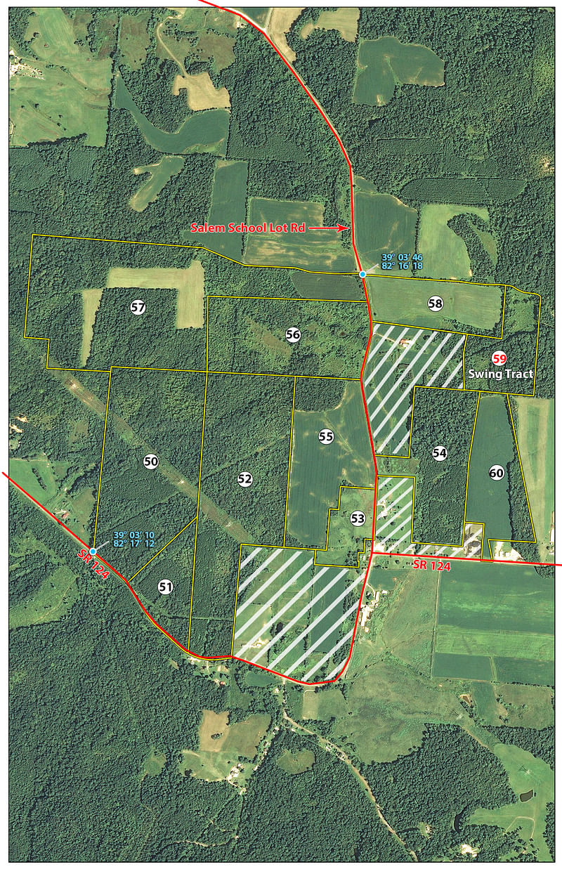
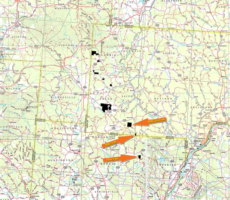
Tract 49: From Wilkesville go approximately 4 miles east on SR 124 to the intersection of Salem School Lot Road and SR 124 go approximately 3.5 miles north on Salem School Lot Road the property is located on the left.
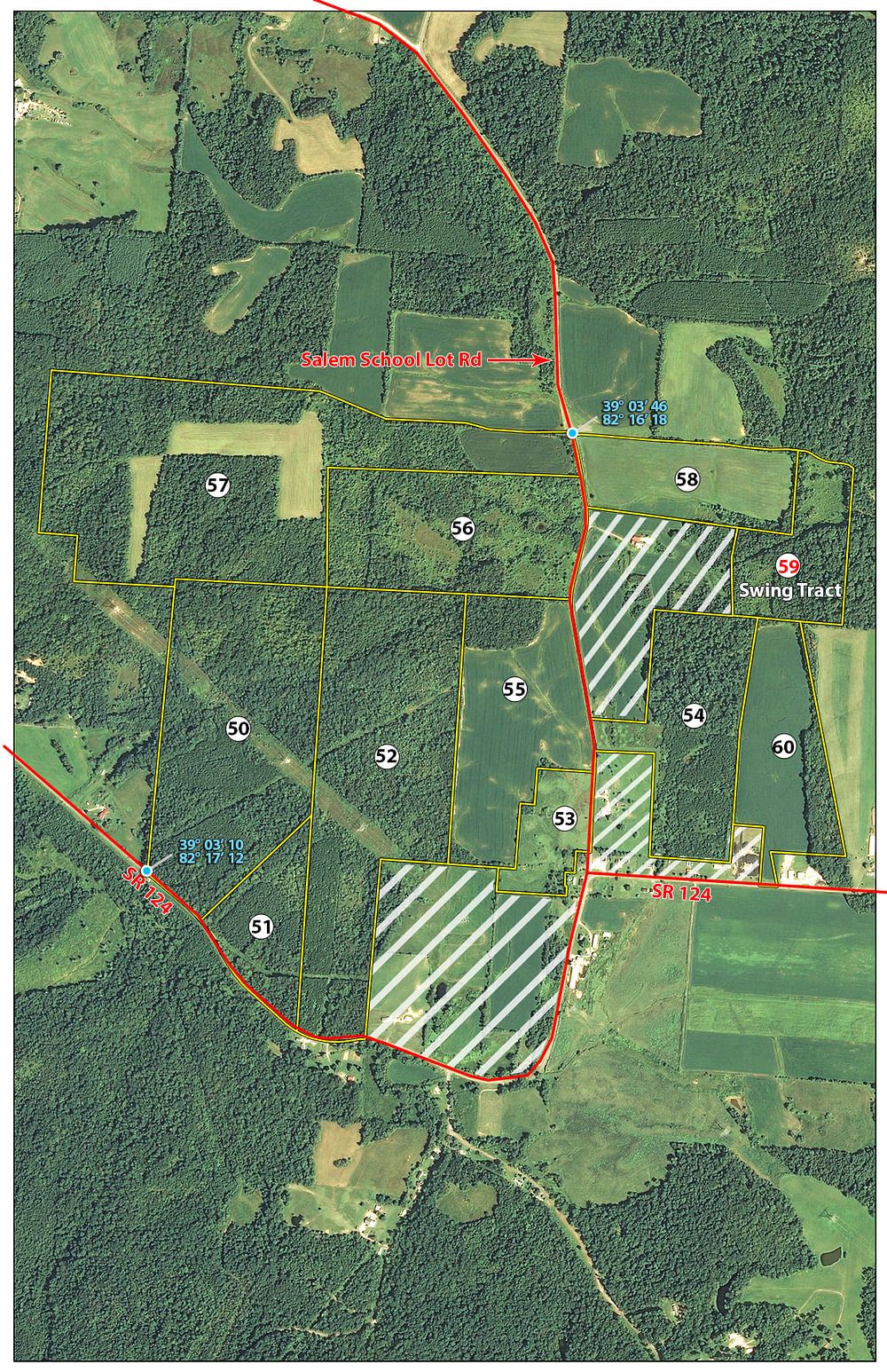
Tracts 50-60: From Wilkesville go approximately 3 miles east on SR 124 tracts 50-52 are on the left side. Proceed 1 mile to Salem School Lot Road turn left/strait and drive approximately 300 feet tracts 53-59 are on the left and right. Tract 60 is located on SR 124, 0.25 miles east from the intersection of Salem School Lot Road and SR 124.
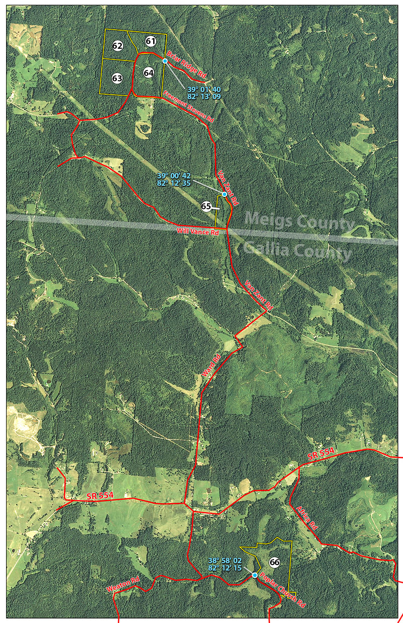
Tracts 61-64: From Wilkesville go approximately 10 miles east on SR 124 to SR 325 turn right on to SR 325 south. Proceed south on SR 325 for approximately 500 feet turn left onto Briar Ridge Road and go 1.5 miles to property on the left and right side of road.
SR 124 will be closed 1 mile east of Salem Center until approx. August 10.
Tract 65: From Wilkesville go approximately 10 miles east on SR 124 to SR 325 turn right on to SR 325 south. Proceed south on SR 325 for approximately 500 feet turn left onto Briar Ridge Road go 1.1 miles to Van Zant Road. Turn left onto Van Zant Road and go approximately 1 mile to property on right side of road. Tract 66: From Cheshire go west on SR 554 approximately 7.8 miles to Weaton Road turn left go 0.6 to Poplar Church Road turn left and go approximately 0.6 miles to property on the left side of road.
AUCTION LOCATION
Athens Community Center, 701 E State Street, Athens, OH 45701
DIRECTIONS: Take exit 15 off US Hwy 33, go east (turn left off ramp) to 3rd stoplight, turn right for the Community Center.
TRACT DESCRIPTIONS
Tract 1: 7± ac
TRACTS 1-29 - Ranging in size from 7+/- to 144+/-acres
Tracts 1 thru 29 vary in size from 7 acres to 144. These tracts feature mixed hardwood trees plus 10-50 year old pine trees on several tracts. A variety of tract sizes, physical features, development potential, possible home sites, recreational/hunting plus investment in timber land make this offering a once in a lifetime opportunity. If you are looking for a wooded home site near Athens be prepared to bid your price. These tracts also offer excellent hunting and recreational opportunities. Various tracts have a network of trails for ATV, hiking or trail riding (horses). This is a rare opportunity to have such a large offering of various wooded land tracts in the Athens area. Be sure and investigate the uniqueness of this land auction. Athens County ranks 5th in the State of Ohio according to Buckeye Big Buck Club for Big Bucks harvested during the past 10 years. Great hunting along with future timber harvest makes this a rare opportunity to enjoy your investment.
Tract 1: 7+/- ac
Tract 2: 65± ac
Tract 3: 19± ac
Tract 4: 16± ac
Tract 5: 34± ac
Tract 6: 42± ac
Tract 7: 144± ac
Tract 8: 0.0± ac
Tract 9: 7.5± ac
Tract 10: 41± ac
Tract 11: 21± ac
Tract 12: 20± ac SWING TRACT
Tract 13: 16± ac SWING TRACT
Tract 14: 25± ac
Tract 15: 36± ac
Tract 16: 16± ac
Tract 17: 26± ac
Tract 18: 12± ac
Tract 19: 22± ac
Tract 20: 14± ac
Tract 21: 57± ac
Tract 22: 18± ac
Tract 23: 20± ac
Tract 24: 20± ac
Tract 25: 18± ac
Tract 26: 58± ac
Tract 27: 18± ac
Tract 28: 31± ac
Tract 29: 15± ac
Tract 30: 50± ac
TRACTS 30-38 - large contiguous property totaling 516+/- acres
This property features mixed hardwood trees plus scattered pines creating prime deer hunting habitat. Muskingum County ranks 2nd in the state of Ohio according to Buckeye Big Buck Club for Big Bucks for all time entries and 3rd in Turkey harvest over the past 10 years. This excellent wildlife habitat has been under Cooperative Agreement with Ohio Department of Natural Resources Division of Wildlife since 1957. There is a total of approximately 2000 acres of land to the North & South of this property that does not allow hunting thus creating a buffer zone around this property. A unique feature on this property is an excellent interior road system ideal for ATVs, trail riding, hiking and access for great hunting. This is a dream come true for the recreational/hunting buyers. Come and enjoy the scenic beauty of this property via an extensive road/trail system. The trail system on this property must be seen to be appreciated. To create the trail/road system on this property would cost thousands of dollars. The trail/road system opens up the scenic beauty and roughness of this property that must be seen to be appreciated (be sure to make an appointment or come to one of the scheduled inspection dates). This property is located just minutes from Zanesville and approximately 45 minutes from Columbus.
Tract 30: 50+/- ac
Tract 31: 34± ac
Tract 32: 87± ac
Tract 33: 5± ac SWING TRACT
Tract 34: 60± ac SWING TRACT
Tract 35: 53± ac
Tract 36: 31± ac
Tract 37: 21± ac
Tract 38: 175± ac
Tract 39: 35± ac
TRACTS 39-66 - ranging in size from 2+/- to 112+/- acres
There is truly something for everyone on these properties that are conveniently located near Athens and Jackson, Ohio, with easy access from Appalachian highway (SR 32) For the hunter or recreational land buyer, many of these tracts offer scenic wooded acreage with outstanding potential for hunting, hiking, ATV riding or any number of outdoor activities. Meigs County ranks 12th in the state according to Buckeye Big Buck Club for deer harvested and 8th last year in turkeys harvested (450 turkeys). Many of these tracts have numerous trails providing easy access to the interior of the various properties to discover the various streams and ponds. For the homesite buyer, investigate the potential for building a home or cabin with fantastic views and a great opportunity to enjoy nature right out your back door! For the farmer or investor, 5 of these tracts include productive tillable farmland totaling approximately 108 acres. A great opportunity for a local farmer to add on to their existing operation! For the larger buyer looking for their own private hunting club, do not miss Tracts 50-60! These tracts, located just east of Wilkesville on SR 124 total over 500 contiguous acres! These tracts also offer a unique combination of mixed hardwood & pine trees, scenic meandering streams (refer to pictures), open meadow area and tillable farmland. The above mentioned features create an excellent wildlife habitat for deer and turkey. This property has it all - water, cover and food - providing for excellent hunting.
Tract 39: 35+/- ac
Tract 40: 56± ac SWING TRACT
Tract 41: 83± ac SWING TRACT
Tract 42: 32± ac
Tract 43: 17± ac
Tract 44: 28± ac
Tract 45: 24± ac
Tract 46: 6± ac
Tract 47: 2± ac
Tract 48: 22± ac
Tract 49: 32± ac
Tract 50: 75± ac
Tract 51: 20± ac
Tract 52: 83± ac
Tract 53: 13± ac
Tract 54: 39± ac
Tract 55: 47± ac
Tract 56: 51± ac
Tract 57: 112± ac
Tract 58: 27± ac
Tract 59: 23± ac SWING TRACT
Tract 60: 30± ac
Tract 61: 30± ac
Tract 62: 37± ac
Tract 63: 46± ac
Tract 64: 52± ac
Tract 65: 18± ac
Tract 66: 71± ac
Tract 67: 10± ac

BUYERS PREMIUM: A three percent (3%) Buyers premium will be added to the final bid price and included in the total purchase price.
PROCEDURE: The property will be offered in sixty six (66) individual tracts, any combination of two (2) or more tracts, and as one (1) entire tract at the date and time noted in this brochure. There will be open bidding on all tracts and combinations during the auction as determined by the Auctioneers. Bids on tracts, tract combinations, and the entire tract may compete.
DOWN PAYMENT: A ten percent (10%) down payment is required on the day of the auction with the balance due in cash at closing. The down payment may be made in the form of cash, cashiers check, personal check, or corporate check. YOUR BIDDING IS NOT CONDITIONAL UPON FINANCING SO BE SURE TO HAVE ARRANGED FINANCING, IF NEEDED, AND THAT YOU ARE CAPABLE OF PAYING CASH AT CLOSING.
ACCEPTANCE OF BID PRICES: All successful bidders will be required to enter into a Real Estate Purchase Contract at the auction site immediately following the close of the auction. All final bid prices are subject to the Sellers acceptance or rejection.
DEED: Seller shall provide a Limited Warranty Deed to Buyer(s) at closing.
EVIDENCE OF TITLE/CONDITION: Seller agrees to furnish bidders a preliminary owners title insurance commitment to review prior to the auction. Seller agrees to provide merchantable title to the property subject to matters of record, general conditions of title, and similar or related matters. Buyer(s) will be responsible for purchasing an owners policy of title insurance if one is desired. All tracts will be sold AS IS-WHERE IS.
REAL ESTATE TAXES: Seller will pay the current year taxes prior to closing or a credit for the current year taxes will be given to Buyer(s) at closing. If the current year taxes are undetermined, Seller shall credit Buyer(s) at closing based on the most recent ascertainable tax figures.
CLOSING: Closing shall take place after January 1, 2016 but prior to March 30, 2016.
POSSESSION: Possession of the land at closing or Buyer(s) may have immediate possession after the auction for hunting privileges by signing a lease which will expire at closing.
ACREAGE: All tract acreages, dimensions, and boundaries are approximate and have been estimated based on current legal descriptions.
MINERALS: The rights being sold are surface only. No minerals will be conveyed.
SURVEY: Seller, at its sole cost and expense, may provide a new survey to the Buyer(s) for the tracts prior to closing. Any need for a new survey shall be determined solely by Seller. If the property purchased is a combination of tracts, the survey shall be for the perimeter of such combination only. The type of survey provided shall be determined by Seller.
PROPERTY INSPECTION: Each potential bidder is responsible for conducting, at their own risk, independent inspections, investigations, inquiries, and due diligence concerning the property. Inspection dates have been scheduled and will be staffed with auction personnel. Each potential bidder shall be liable for any property damage caused by any such inspections or investigations.
AGENCY: Schrader Real Estate and Auction Company Inc., Murray Wise Associates LLC and its representatives (the Auctioneers) are the auctioneers and exclusive agents of the Seller regarding the sale of the property.
DISCLAIMER AND ABSENCE OF WARRANTIES: All information contained in this brochure and all related materials are subject to the terms and conditions outlined in the Real Estate Purchase Contract. ANNOUNCEMENTS MADE BY THE AUCTIONEERS AT THE AUCTION PODIUM DURING THE TIME OF THE SALE WILL TAKE PRECEDENCE OVER ANY PREVIOUSLY PRINTED MATERIAL OR ANY OTHER ORAL STATEMENTS MADE. The property is sold AS IS-WHERE IS. No warranty or representation, either express or implied, or arising by operation of law concerning the property is made by Seller or the Auctioneers and are hereby expressly disclaimed. In no event shall Seller or the Auctioneers be liable for any consequential damages. The information contained in this brochure is believed to be accurate but subject to verification by all parties relying on it. Seller and the Auctioneers assume no liability for its accuracy, errors or omissions. All sketches and dimensions in this brochure are approximate. Conduct of the auction and increments of bidding are at the direction and discretion of the Auctioneers. Seller and the Auctioneers reserve the right to preclude any person from bidding if there are any questions, in the sole judgment of Seller or the Auctioneers, as to such persons creditworthiness, ability or willingness to close on the purchase of the property, credentials, fitness, etc. All decisions of Seller and the Auctioneers are final.
NEW DATA, CORRECTIONS AND CHANGES: Please arrive prior to the scheduled auction time to review any changes, corrections, or additions to the property information.
SELLER: Ohio Franklin Realty, LLC
RD SCHRADER, CAI
(800) 451-2709
Email Agent
Download the PDF or Mail me this brochure
Email this information to a friend