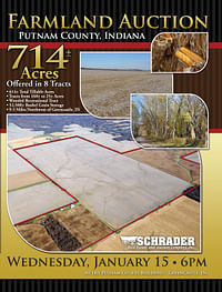
714+/- Acres Offered in 8 Tracts, FARMLAND AUCTION
Wed, Jan 15, 6:00 PM
Greencastle, Indiana, Putnam County
Owner: M&O FARMS LLC
• FARMLAND AUCTION
• 714+/- Acres Offered in 8 Tracts
• 614+/- Total Tillable Acres
• Tracts from 160+/- to 25+/- Acres
• Wooded Recreational Tract
• Top quality productive Putnam County farmland
• 5 grain bins with updated electrical service and Total Storage Capacity of 52,500 Bushel, 500 contiguous acres in parent tract
• 86% tillable farm, large tracts and small tracts available
• 614+/- Total Tillable Acres Available for 2014 Growing Season
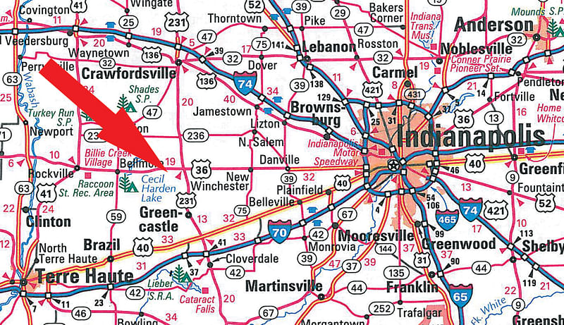
• 23.5 miles West of Danville, IN
• 14 miles East of Rockville, IN
• 9.5 miles Northwest of Greencastle, IN
• Auctioneers Note: A rare opportunity to purchase this much quality tillable farmland in Putnam County in one auction!
OPEN HOUSE/INSPECTION DATES
Meet Bill and Todd at the farm on Tract #6 at the grain bin location on the following dates:
Saturday, December 21st from 10AM - Noon
Saturday, January 4th from 10AM - Noon
Wednesday, January 15th (Sale Day)from 4-5PM
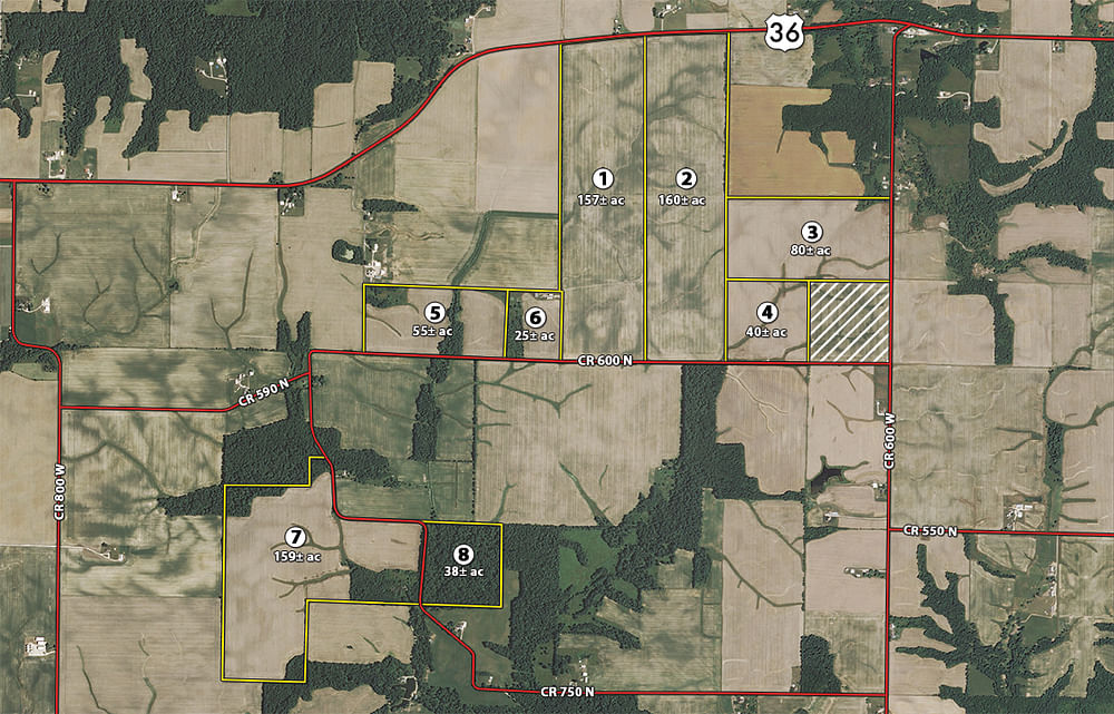
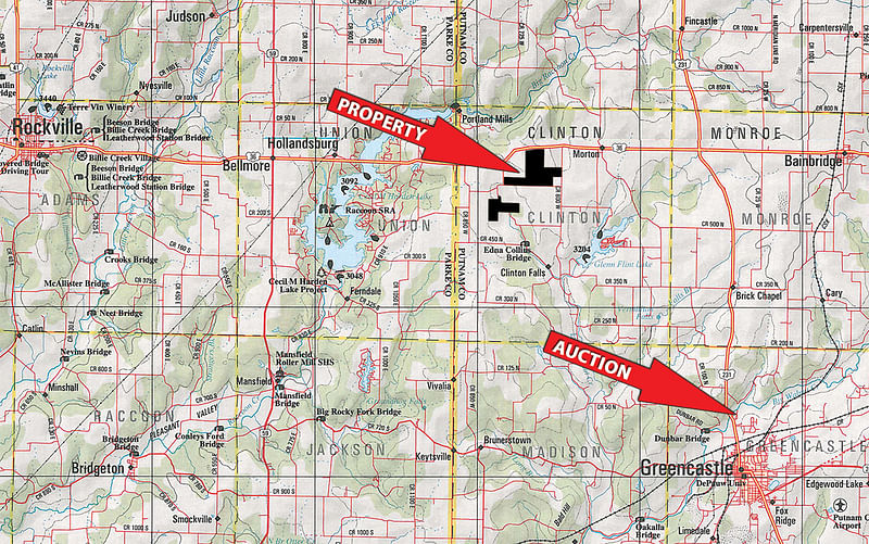
PROPERTY LOCATION
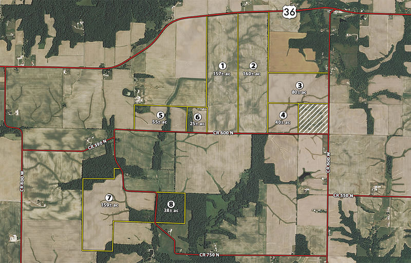
From the intersection of US Highway 36 & State Road 231 travel West approximately 4.5 miles, Tracts 1 through 6 are located on the south side of the highway between County Road 600W and County Road 775W. Follow either 600W or 775W south to wrap around the south side of Tracts 1 - 6. Tracts 7 & 8 are accessible by driving South along County Road 775W, turn west on County Road 600N and immediately south again on County Road 775W about 3/4 of a mile to Tracts 7 & 8 situated on the south side of the road.
From West: Take US Highway 36 from Rockville Indiana East 14 miles to farm situated between 775W and 600W.
AUCTION LOCATION
Putnam County Fairgrounds, Greencastle, Indiana.
Located on the north side of Greencastle along the east side of Highway 231. From the intersection of US36 & Highway 231 travel south approximately 7 miles to Fairgrounds, on east side of the road.
TRACT DESCRIPTIONS
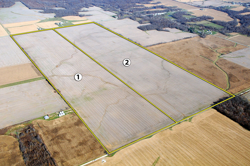
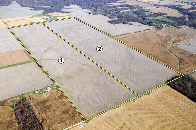
Tract 1: 157± ac - 153+/- tillable acres with 1200 ft. of road frontage on CR 600N & US36. High producing soils; Reesville and Ragsdale are predominant across this tract.
Tract 2: 160± ac - 155+/- tillable acres with 1200 ft. of frontage on CR 600N & US36. High producing soils; Reesville and Ragsdale are predominant.
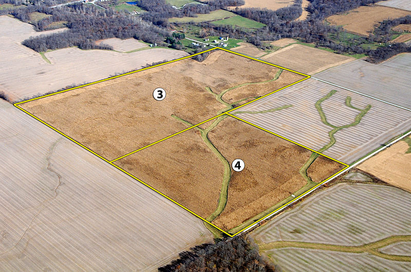
Tract 3: 80± ac - 75+/- tillable acres with 1250 ft. of frontage along CR 600W. High producing soils; Reesville and Ragsdale are predominant.
Tract 4: 40± ac - 36+/- tillable acres with 1300 ft. of road frontage on CR 600N. Predominant Soils are Reesville and Xenia.
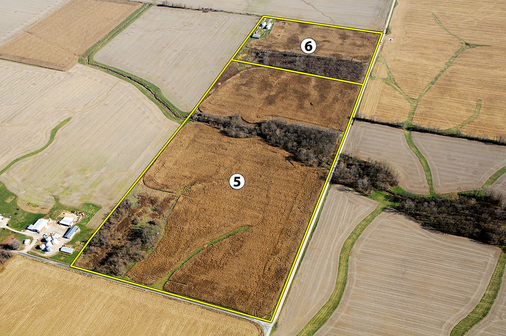
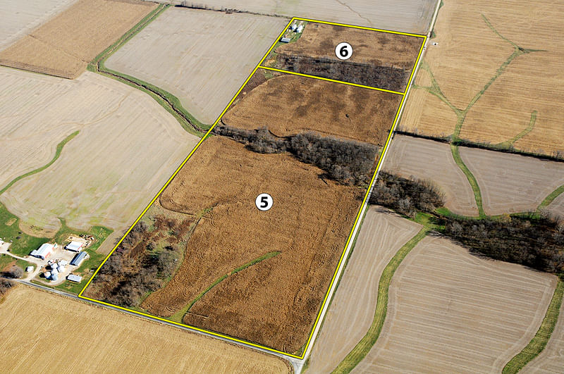
Tract 5: 55± ac - 47+/- tillable acres with 2100 ft. of road frontage on CR 600N & 1000 ft. of road frontage along CR 775W. High producing soils Reesville and Russell are predominant.
Tract 6: 25± ac - 15+/- tillable acres with 900 ft. of road frontage on CR 600N & 5 grain bins with updated electrical service, total storage is 52,500+/- bushels and 60 ft. x 60 ft. barn. High producing soil Reesville and Xenia are predominant.
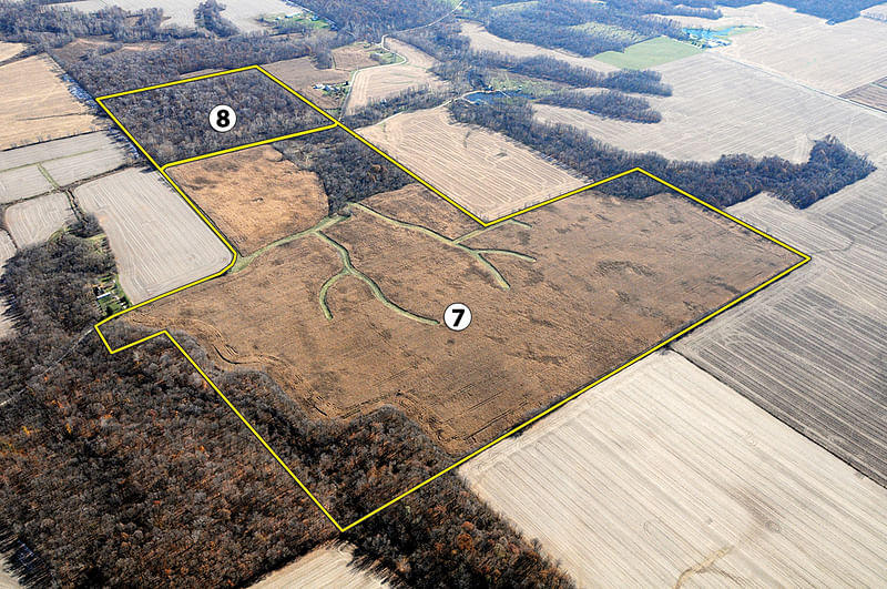
Tract 7: 159± ac - 133+/- tillable acres with 1000 ft. of road frontage on CR 775W. High producing soils; Reesville and Ragsdale are predominant.
Tract 8: 38± ac 1600 ft. of road frontage on CR 775W. This tract is all wooded and would make an ideal recreational tract.
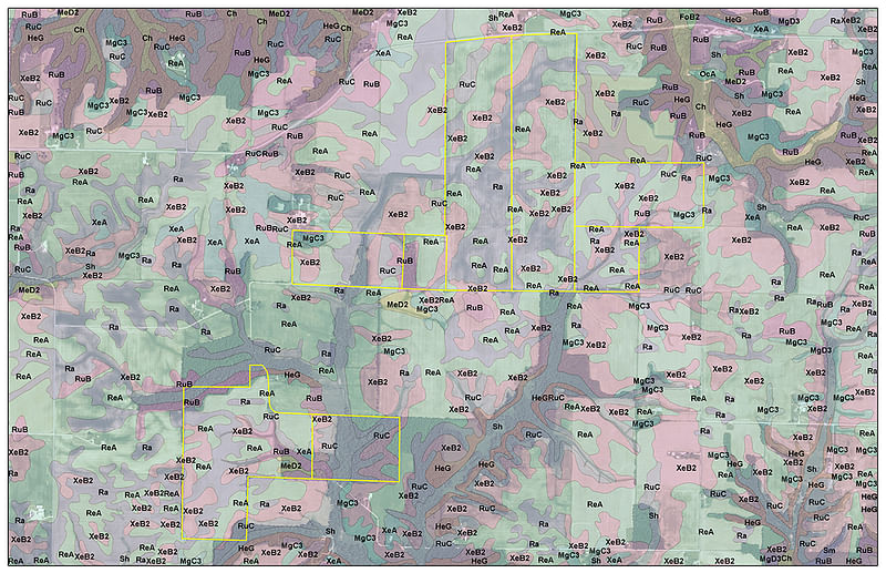
SOIL INFORMATION
PROCEDURE: This property will be offered in 8 individual tracts, combination of tracts, or as a total 714.15+/- acre unit. The property will be sold in the manner resulting in the highest total sale price.
ACCEPTANCE OF BID PRICES: All successful bidders will be required to enter into purchase agreements at the auction site immediately following the close of the auction. All final bid prices are subject to the Sellers acceptance or rejection.
DOWN PAYMENT: 10% down payment on the day of auction with the balance in cash at closing. The down payment may be made in the form of cashiers check, personal check, or corporate check. YOUR BIDDING IS NOT CONDITIONAL UPON FINANCING, SO BE SURE YOU HAVE ARRANGED FINANCING, IF NEEDED, AND ARE CAPABLE OF PAYING CASH AT CLOSING.
BUYERS PREMIUM: A 2% Buyers Premium will be added to the high bid(s) to determine the Contract Purchase Price.
CLOSING: The balance of the purchase price is due at closing, which shall take place within 10 days from delivery of marketable title. Closing on or about February 21, 2014 is anticipated. Closing costs for an administered closing shall be shared 50:50 between Buyer(s) and Sellers.
EVIDENCE OF TITLE: Seller shall provide a Limited Liability Company Warranty Deed in the amount of the contract purchase price.
POSSESSION: Possession shall be given at closing, subject to Tenants Rights to harvest the existing crop. Possession of the improvements will be immediately upon closing. Grain bin possession will be May 1, 2014.
REAL ESTATE TAXES: Buyer shall assume the 2014 real estate taxes due in 2015. Buyer shall assume any Ditch Assessments due in 2014 and thereafter.
ACREAGE: All tract acreages, dimensions and proposed boundaries are approximate and have been estimated based on aerial photos and the current legal description.
FSA INFORMATION: The Montgomery County FSA Office shall make all acreage and base yield determinations.
EASEMENTS: Sale of the property is subject to any and all easements of record.
MINERAL RIGHTS: The sale shall include 100% of the mineral rights owned by the Seller, if any.
SURVEY: Current legal descriptions shall be used to convey the property on tracts 3 & 4. If tracts 1, 2 and 5 thru 8 are purchased individually a new survey will be required. If tracts 1 & 2, 5 & 6 or 7 & 8 are purchased together, existing legal description will be used to convey the auction tracts. Any need for a new survey will be determined solely by the Sellers. The type of survey performed shall be at the Sellers option sufficient for providing title insurance. Closing prices shall be adjusted to reflect any difference between advertised and surveyed acres, if a new survey is determined to be necessary by the Sellers. The adjustments will be made only on tracts or combination of tracts that do not contain improvements.
AGENCY: Schrader Real Estate and Auction Company, Inc. and its representatives are exclusive agents of the Seller.
DISCLAIMER AND ABSENCE OF WARRANTIES: All information contained in this brochure and all related materials are subject to the terms and conditions outlined in the Purchase Agreement. The property is being sold on an AS IS, WHERE IS basis, and no warranty or representation either expressed or implied, concerning the property is made by the Sellers or the Auction Company. All sketches and dimensions in the brochure are approximate. Each potential bidder is responsible for conduction his or her own independent inspections, investigations, inquiries, and due diligence concerning the property. The information contained in this brochure is subject to verification by all parties relying on it. No liability for its accuracy, errors, or omissions is assumed by Sellers or the Auction Company. Conduct of the auction and increments of bidding are at the direction and discretion of the Auctioneer. The Sellers and Selling Agents reserve the right to preclude any person from bidding if there is any question as to the persons credentials, fitness, etc. All decisions of the Auctioneer are final.
ANNOUNCEMENTS MADE BY THE AUCTION COMPANY AT THE AUCTION PODIUM DURING THE TIME OF THE SALE WILL TAKE PRECEDENCE OVER ANY PREVIOUSLY PRINTED MATERIAL, OR ANY OTHER ORAL STATEMENTS MADE.
TODD FREEMAN
(765) 379-3567
(765) 414-1863 (cell)
Email Agent
BILL HAWORTH
(800) 451-2709
(317) 445-4246 (cell)
Email Agent
Download the PDF or Mail me this brochure
Email this information to a friend